Logo

Detect earlier. Verify faster. Act with intelligence.

Powered by TACTICAᴬᴵ

TACTICAAI agentically observes, reasons, and recommends across spaceborne, maritime, and terrestrial data. Total operational clarity and decision advantage.

SCROLL

LAT 24.5° N, LON 54.3° E ALT: 561km | FOV: 2200km

About

What TACTICAAI Is

TACTICAAI is a multi‑domain decision‑support platform designed to transform raw sensor data into actionable situational intelligence.

From Data to Decisions

  • Connect any sensor: Seamlessly plug in existing imaging platforms, CCTVs, IoT sensors, data feeds, and more
  • Deploy autonomous agents: Agentic orchestration of intelligence workflows. AI-based reasoning, explanation, and course-of-action generation
  • Always-on analytics: TACTICAAI constantly interprets incoming data to provide proactive alerts and reports
  • Human-in-the-loop intelligence: Ensure trust, validation, and accountability

Digital Twin

  • See the situation: Interactive 3D environment for cross-domain situational awareness across land, sea, and infrastructure sites
  • Understand the context: Holistic analysis of fused data to reveal cross-domain correlations and build a nuanced operational picture
  • Plan your move: Simulation and analysis of scenarios, risks, and predicted outcomes powered by AI reasoning

Domains

Utilities &
Infrastructure

  • Power grid & energy asset monitoring
  • Infrastructure deformation & integrity detection
  • Predictive maintenance for linear assets (pipelines, rail, roads)
  • Solar farm analysis, site suitability & performance tracking
  • Perimeter security & intrusion detection for critical assets

Maritime &
Coastal

  • Vessel detection, tracking & classification (AIS + non-AIS)
  • Port activity, congestion & dwell-time analytics
  • Route deviation & behavioral anomaly detection
  • Illegal fishing & dark vessel identification
  • Environmental monitoring (oil spills, weather & sea-state hazards)

Agriculture &
Environment

  • Crop health, vegetation & biomass monitoring
  • Soil moisture, irrigation & water resource analysis
  • Air & water quality monitoring
  • Climate impact assessment & land degradation tracking
  • Ecosystem monitoring (wetlands, mangroves, coral reefs)

Disaster Management & Emergency Response

  • Flood, fire & extreme weather impact assessment
  • Earthquake, landslide & structural damage detection
  • Emergency mobility & access-route planning
  • Search-and-rescue situational awareness
  • Humanitarian relief & resource allocation mapping

Civil Defense
& Security

  • Perimeter & intrusion detection (ground, UAV, maritime)
  • Crowd density & event monitoring
  • Cross-border activity & anomaly detection
  • Integrated site security & digital twin operations
  • Suspicious vehicle, convoy & route behavior analysis

Urban
Management

  • Traffic flow, congestion & travel-time analytics
  • Public transport monitoring & fleet optimization
  • Construction progress & urban growth tracking
  • Energy consumption & utility efficiency mapping
  • City-wide operational intelligence & smart infrastructure monitoring

Missions

TACTICAAI organizes capabilities around missions — the real-world outcomes our customers need to achieve.

Image

Earth Observation

  • - Flood & Extreme Weather Intelligence
  • - Coastal & Marine Ecosystem Monitoring
  • - Infrastructure Deformation & Subsidence
Image

Maritime

  • - Illegal & Anomalous Vessel Detection
  • - Oil Spill & Marine Pollution Response
Image

Security

  • - Critical Infrastructure Protection
  • - Urban Situational Awareness

What TACTICAAI Offers

End-to-end intelligence, from observation to action

Icon
Act and Monitor

Support live operations with dashboards, alerts, and digital twin visualization

Icon
Report

Deliver auditable reports and capture lessons learned.

Icon
Sense

Receive data from satellites, AIS, CCTV, UAVs, IoT sensors, and legacy systems

Icon
Fuse

Align and cross-validate multi-source data across space and time

Icon
Reason

AI agents orchestrate analytics, detect anomalies, and assess risk

Icon
Decide

Generate prioritized insights, recommended actions, and mission workflows

Drag
Icon
Act and Monitor

Support live operations with dashboards, alerts, and digital twin visualization

Icon
Report

Deliver auditable reports and capture lessons learned.

Icon
Sense

Receive data from satellites, AIS, CCTV, UAVs, IoT sensors, and legacy systems

Icon
Fuse

Align and cross-validate multi-source data across space and time

Icon
Reason

AI agents orchestrate analytics, detect anomalies, and assess risk

Icon
Decide

Generate prioritized insights, recommended actions, and mission workflows

Icon
Act and Monitor

Support live operations with dashboards, alerts, and digital twin visualization

Icon
Report

Deliver auditable reports and capture lessons learned.

Icon
Sense

Receive data from satellites, AIS, CCTV, UAVs, IoT sensors, and legacy systems

Icon
Fuse

Align and cross-validate multi-source data across space and time

Icon
Reason

AI agents orchestrate analytics, detect anomalies, and assess risk

Icon
Decide

Generate prioritized insights, recommended actions, and mission workflows

Multi-Sensor
Technology Stack

TACTICAAI is sensor-agnostic, integrating seamlessly with existing infrastructure

Sensors

Optical, SAR, LiDAR, hyperspectral, AIS, CCTV, IoT, GNSS, GRACE‑FO

Fusion & Reasoning

  • Cross‑domain data fusion (EO, maritime, security, IoT)
  • AI‑based anomaly detection and behavioral analysis
  • Predictive intelligence and early‑warning generation
  • Human‑in‑the‑loop validation for critical decisions

Data & AI Layer

  • AI vision and geospatial models
  • InSAR and physics‑based analytics
  • Event‑driven and streaming analytics
  • Agentic AI orchestration layer coordinating models, sensors, and tasks
  • Generative AI / LLMs for reasoning, summarization, and decision support

Digital Twin & Interfaces

  • 3D visualization, dashboards, alerts, reporting

Vision

Why Multi‑Domain
Intelligence Matters

You don’t need more sensors; you need clearer answers. Today’s operations are paralyzed by fragmented data silos across satellites, cameras, IoT networks, and beyond. In this complex environment, critical insights never make it to the surface.

TACTICAAI multi-domain intelligence opens the silos, fusing discrete data streams into a single operational picture that supports faster, more authoritative decision-making

AI‑Driven Situation
Awareness

TACTICAAI uses AI to orchestrate complex streams of satellite imagery, sensor data, and operational signals in real time. The platform detects anomalies, correlates events across domains, and delivers contextual intelligence, helping operators identify risks earlier, prioritize responses, and act with greater speed and clarity.

Partnerships

TACTICAAI collaborates with global satellite providers, research institutes, and technology partners to accelerate innovation in Earth intelligence and AI-driven situational awareness. These partnerships expand access to high-quality sensor data while advancing new capabilities in geospatial analytics, autonomous intelligence systems, and multi-domain monitoring.

Alignment with UAE Vision
& National AI Strategy

TACTICAAI supports the UAE’s ambition to lead in advanced technology and AI-enabled decision systems. By developing sovereign intelligence capabilities and integrating space, maritime, and terrestrial sensing, the platform contributes to national resilience, economic growth, and sustainable development aligned with the UAE’s AI and innovation strategies.

Ethical &
Responsible AI

Responsible AI is central to TACTICAAI’s development. The platform integrates human oversight, transparent analytical workflows, and secure data governance to ensure intelligence outputs remain trustworthy and accountable. By embedding fairness, privacy protection, and reliability into system design, TACTICAAI enables confident deployment in mission-critical environments.

News

06 MAY 2026
ABU DHABI

TACTICAAI Introduces Region’s First AI Platform for Mission-Critical, Real-Time Operational Decisions

News

Built on deep tech developed by TII, TACTICAAI moves beyond dashboards to help decision-makers turn fragmented intelligence, sensor, and operational data into action

Read More
30 APRIL 2026
ABU DHABI

SATIM OREC AI-based SAR Analytics to be integrated into TacticaAI – Pulse Platform

News

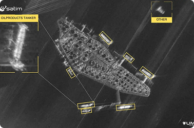
SATIM, a Polish SAR-AI specialist, announces its partnership with TacticaAI to provide SAR intelligence to strengthen regional ISR capabilities in the UAE.

Read More

Contact

For collaborations, demonstrations, or partnerships across Earth Observation, Maritime, or Security domains