
The New Era of Earth Intelligence
Earth Observation (EO) is entering an era in which the ability to collect data is advancing faster than the ability to transform it into timely, decision-relevant intelligence. Expanding satellite constellations, diverse sensing modalities, and complementary data streams are generating unprecedented volumes of information, yet traditional sensor-centric and linear processing workflows remain constrained by fragmentation, analytical complexity, and the pace of human interpretation.
Closing this data-to-decision gap requires a shift from isolated analytics toward fusion-first, decision-centric intelligence systems. Next-generation EO architectures must integrate heterogeneous observations across sensors, domains, and time; coordinate specialized analytical capabilities dynamically; preserve uncertainty and provenance; and translate evolving evidence into coherent situational awareness. Advances in agentic AI, large language models (LLMs), and geospatial reasoning provide new mechanisms for orchestrating these capabilities around user intent and operational objectives while retaining human oversight.
This white paper examines the transition from conventional EO pipelines toward AI-native, agentically orchestrated intelligence systems. It presents architectural principles for multi-source fusion, composable analytics, adaptive orchestration, and trustworthy decision support, and illustrates their application across disaster response, environmental monitoring, infrastructure resilience, maritime domain awareness, geospatial decision intelligence, and sensor tasking. Together, these developments point toward a broader evolution of EO: from the production of data and analytical products toward an adaptive intelligence infrastructure capable of supporting faster, more contextual, and more informed decisions.
From orbit, Earth reveals a kaleidoscope of evolving patterns. Rivers meander through forests, cities pulse with light, and coastlines shift and reform after each storm. These patterns are more than static snapshots; they are signals of change. Each observation can provide insight into planetary health, infrastructure resilience, human activity, and the complex interactions between natural and built environments.
Over the 21st century, Earth Observation (EO) has become an increasingly important component of modern decision-making. It supports national security, disaster response, environmental monitoring, infrastructure planning, maritime awareness, and humanitarian operations. Yet the traditional EO paradigm—where imagery is acquired, processed through predefined workflows, and subsequently interpreted by analysts—is increasingly challenged by the scale, diversity, and speed of contemporary sensing.
The fundamental constraint is shifting. The world is no longer limited primarily by the ability to observe; it is increasingly limited by the ability to synthesize observations into timely and contextualized intelligence. Optical imagery, Synthetic Aperture Radar (SAR), thermal observations, in-situ sensors, maritime signals, meteorological models, and contextual information often remain distributed across separate systems and analytical workflows. Real- world events, however, do not respect these boundaries. Floods interact with terrain and infrastructure; maritime activity is shaped by environmental conditions and navigational access; infrastructure risk emerges through the interaction of physical change, operational context, and time. Without coherent integration, increasing data volume can amplify complexity rather than improve understanding.
The scale of this challenge continues to grow. According to Novaspace, approximately 5,401 Earth Observation satellites are projected to be launched between 2024 and 2033, representing nearly a 190% increase over the previous decade [1]. Over the same period, EO satellite manufacturing revenues are forecast to reach $131.0 billion, with an additional $40.1 billion in launch revenues [1]. Complementing this expansion in sensing infrastructure, a 2024 World Economic Forum analysis estimates that broader adoption of EO data and services could contribute up to $3.8 trillion in cumulative global GDP impact between 2023 and 2030 [2]. Realizing this value, however, depends not simply on collecting more data, but on transforming heterogeneous observations into coherent, timely, and trustworthy intelligence.
Artificial intelligence has already begun to accelerate individual stages of this process through automated detection, segmentation, change analysis, predictive modelling, and event-driven processing. These capabilities represent significant progress, but isolated models alone do not resolve the broader architectural challenge. A collection of high-performing analytics can still remain fragmented if the system cannot determine which data to use, which analytical capabilities to invoke, how to correlate results across domains, how to manage uncertainty, and how to translate findings into operationally relevant outputs.
The emerging challenge for EO is therefore not simply one of data processing, but of intelligence orchestration. Next-generation systems must connect heterogeneous observations, specialized analytical models, contextual information, and human expertise within architectures capable of adapting to evolving objectives and evidence. This requires a transition from predefined, sensor-centric processing pipelines toward fusion-first, decision-centric intelligence systems.
The following section examines this architectural transition—from processing individual observations and producing analytical products toward maintaining an evolving understanding of the operational environment—and the role of multi-source fusion, composable analytics, agentic AI, and geospatial reasoning in enabling it.
Traditional Earth Observation architectures have largely been organized around predefined processing pipelines. Data is acquired, preprocessed, analyzed, and ultimately transformed into maps, reports, or alerts. This model remains effective for many established applications, but it is inherently task-oriented: workflows are typically designed around specific sensors, analytical methods, and expected outputs.
Next-generation EO systems require a different operating model. Rather than processing each observation through an isolated workflow, they must maintain an evolving representation of the operational environment by integrating evidence across sensors, domains, and time. New observations may reinforce, contradict, or change an existing interpretation, while emerging events may require different analytical capabilities to be invoked as the situation develops. The objective therefore shifts from processing imagery and producing products to maintaining situational understanding.
This transition also changes the role of analytics. Specialized capabilities—including change detection, object detection, segmentation, interferometry, spectral analysis, environmental modelling, and predictive analytics—remain essential, but they increasingly need to operate as composable capabilities within a broader intelligence system. Depending on the mission objective, available data, and emerging evidence, different analytical components may need to be selected, sequenced, combined, or revisited rather than executed through a fixed processing chain.
Such systems must operate across multiple dimensions simultaneously: multi- sensor, multi-source, multi-scale, multi-domain, and multi-temporal. They must align heterogeneous observations across space and time, preserve contextual relationships between them, and communicate uncertainty rather than obscure it. Equally important, they must connect analytical outputs with operational context so that detections and measurements can be interpreted in terms of their potential significance.
The transition from EO pipelines to intelligence systems is therefore not simply an improvement in processing speed or model performance. It represents a structural change in how Earth Observation capabilities are organized and operationalized: from predefined workflows that produce individual analytical products toward adaptive systems that integrate evidence, coordinate analytical capabilities, and progressively refine understanding as new information becomes available.
The following section examines the technical and architectural principles that enable this transition, including multi-source fusion, spatio-temporal harmonization, composable analytics, and agentic orchestration.
The transition from conventional EO pipelines to intelligence systems requires more than the addition of individual AI models. It depends on architectural capabilities that allow heterogeneous observations, analytical tools, and contextual information to operate as parts of a coordinated system. Four technical differentiators are particularly important: fusion by design, spatio- temporal and uncertainty-aware alignment, adaptive orchestration, and lifecycle traceability.
A first differentiator is fusion by design rather than aggregation by convenience. Effective fusion is not achieved simply by stacking datasets or overlaying information on a common map. Optical imagery, Synthetic Aperture Radar (SAR), thermal observations, LiDAR, in-situ measurements, maritime signals, and contextual datasets differ in spatial resolution, temporal cadence, latency, noise characteristics, and physical meaning. Intelligence systems must therefore align and interpret these sources as complementary evidence about an evolving environment rather than as independent analytical products.
This requires spatio-temporal and uncertainty-aware reasoning. Observations rarely coincide perfectly in space or time: cloud cover may obscure optical imagery; SAR may provide structural information but limited spectral context; in-situ sensors may offer high temporal resolution but sparse spatial coverage. Rather than suppressing these differences, intelligence systems must preserve temporal context, account for varying confidence, and propagate uncertainty into downstream interpretation. The objective is not merely to detect features at the pixel level, but to reason over environmental, infrastructure, and operational states as they evolve.
A second major differentiator is adaptive orchestration. Traditional EO workflows execute processing chains defined in advance. In contrast, agentic architectures treat datasets, analytical models, geospatial functions, and external services as composable capabilities that can be selected, invoked, sequenced, or revisited according to user intent, data availability, mission objectives, and emerging evidence. This enables the system to move beyond executing a predefined workflow toward coordinating the analytical process itself.
Large language models (LLMs) and emerging geospatial language models (GeoLLMs) can support this orchestration layer by interpreting natural- language objectives, structuring complex evidence, coordinating tools and workflows, and synthesizing multi-source outputs. Their role is not to replace specialized EO models or human expertise, but to connect them within a broader reasoning framework. When grounded in structured geospatial data and governed by explicit constraints, such models can help translate user intent into analytical tasks while supporting iterative investigation and contextual interpretation.
A final differentiator is traceability across the intelligence lifecycle. As analytical workflows become more adaptive, systems must maintain clear links between source observations, processing steps, model outputs, intermediate inferences, and decision-level products. Provenance, uncertainty, and human validation must remain visible throughout the workflow. This supports auditability, explainability, bias assessment, and governance—particularly where EO-derived intelligence informs infrastructure, environmental, humanitarian, or security decisions.
Taken together, these capabilities mark a transition from isolated analytics toward coordinated intelligence systems. Fusion provides the evidence base; spatio-temporal alignment establishes context; specialized analytics extract information; agentic orchestration coordinates the workflow; and traceability preserves trust. The resulting architecture is presented in Figure 1.
The principles described above can be organized into a layered intelligence architecture that connects heterogeneous observations with data fusion, specialized analytics, agentic orchestration, human validation, and decision support. As illustrated in Figure 1, the architecture is designed around the transformation of multi-source data into agentic decision intelligence, rather than around any single sensor, analytical model, or application domain.
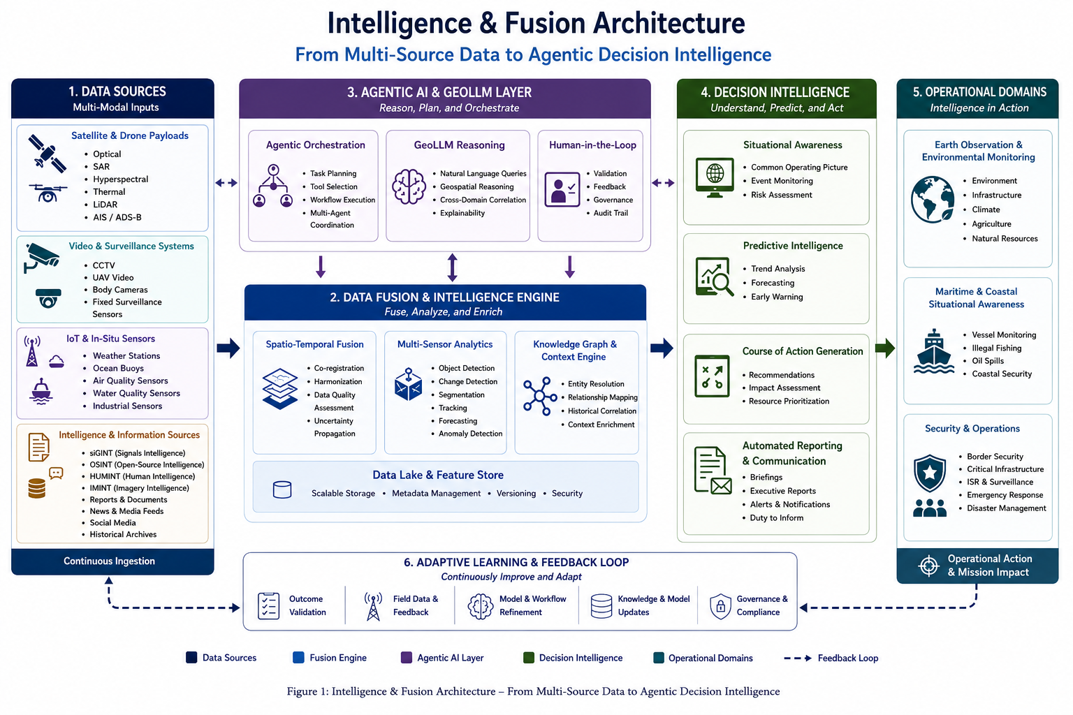
Figure 1: Intelligence and Fusion Architecture for transforming multi-source data into agentic decision intelligence. Multi- modal data and intelligence sources are integrated through a Data Fusion and Intelligence Engine and dynamically coordinated through an Agentic AI and GeoLLM layer incorporating human-in-the-loop validation. The resulting intelligence supports situational awareness, predictive assessment, course-of-action generation, automated reporting, and operational applications across environmental, maritime, and security domains, with an adaptive feedback loop enabling continuous refinement.
At the foundation are multi-modal data and intelligence sources spanning orbital, aerial, terrestrial, and contextual domains. These may include satellite and drone payloads; video and surveillance systems; IoT and in-situ sensors; and broader intelligence and information sources such as SIGINT, OSINT, HUMINT, IMINT, reports, social media, news, and historical archives. Continuous ingestion enables these heterogeneous sources to contribute to a shared analytical environment as new information becomes available.
The Data Fusion and Intelligence Engine provides the analytical foundation of the architecture. Incoming observations are harmonized across space, time, resolution, and metadata, while uncertainty and data quality are preserved throughout the workflow. Specialized capabilities—including object detection, change detection, segmentation, tracking, forecasting, and anomaly detection—operate alongside knowledge graphs and contextual reasoning mechanisms that support entity resolution, relationship mapping, historical correlation, and broader interpretation. A scalable data lake and feature store provides the persistent data foundation required to support repeated analysis, model execution, and evolving intelligence workflows.
The central architectural shift is the introduction of an Agentic AI and GeoLLM layer that interacts dynamically with the underlying fusion and analytics environment. Rather than relying solely on predefined processing chains, agentic orchestration can interpret mission objectives, select appropriate tools and data, coordinate multi-step workflows, and adapt the analytical sequence as new evidence or constraints emerge. GeoLLM capabilities support natural- language interaction, geospatial reasoning, cross-domain correlation, and explanation, while human-in-the-loop mechanisms enable validation, feedback, governance, and auditability. The objective is not to replace specialized analytical models or domain experts, but to coordinate them within a broader reasoning and decision-support framework.
The resulting evidence is translated into decision intelligence. Depending on the operational context, this may include a common operating picture, event monitoring, risk assessment, trend analysis, forecasting, early warning, recommended courses of action, impact assessment, resource prioritization, automated reporting, and alerts. Importantly, the architecture extends beyond presenting analytical outputs: it seeks to connect observations and evidence with the operational decisions they are intended to support.
These capabilities can be applied across multiple operational domains, including Earth Observation and environmental monitoring, maritime and coastal situational awareness, and security and operational applications. The same underlying architecture can therefore support different mission contexts without requiring each domain to operate as an isolated analytical system. Domain- specific models, data sources, constraints, and workflows remain specialized, while fusion, orchestration, reasoning, and decision-support capabilities provide a common architectural foundation.
Finally, the architecture incorporates an adaptive learning and feedback loop connecting operational outcomes back to the intelligence process. Outcome validation, field observations, analyst feedback, model and workflow refinement, knowledge updates, and governance requirements can continuously inform subsequent analysis. In this way, the system is not conceived as a one- directional pipeline ending with an alert or report, but as an adaptive intelligence cycle in which operational feedback can refine models, workflows, contextual knowledge, and future observations.
Figure 1 therefore represents more than a conventional data-processing stack. It describes a transition from data ingestion and isolated analytics toward an adaptive intelligence architecture in which heterogeneous observations are fused, specialized capabilities are coordinated around mission objectives, human oversight is embedded within the reasoning process, and resulting intelligence supports operational action and continuous refinement. The following section illustrates how different elements of this architecture are already emerging across real-world applications and operational platforms.
To ground the preceding architectural discussion in real-world contexts, this section presents a set of illustrative operational scenarios demonstrating how fusion-first, agentic intelligence systems translate heterogeneous sensing and contextual data into decision-relevant intelligence. The examples span environmental monitoring, disaster response, infrastructure resilience, maritime domain awareness, geospatial decision intelligence, and sensor tasking, illustrating how the architectural principles described above can be applied across different operational domains.
Each case highlights a distinct dimension of next-generation intelligence—including cross-domain fusion, spatio-temporal harmonization, uncertainty-aware interpretation, contextual reasoning, and adaptive orchestration. Together, these examples illustrate how integrated architectures can progress from sensing and analytics toward situational understanding, decision support, and operational action.
Volcanic sulfur dioxide (SO₂) emissions pose a dynamic atmospheric hazard with implications for environmental monitoring, public safety, and aviation operations. In this scenario, satellite observations sensitive to atmospheric SO₂ concentrations were processed to identify plume extent and temporal evolution following volcanic activity. The analysis used satellite-derived trace-gas observations to delineate areas of elevated SO₂ concentration and characterize the evolving spatial distribution of the plume.
To place the atmospheric signal in an operational context, plume-derived products were combined with aircraft traffic data obtained from Automatic Dependent Surveillance–Broadcast (ADS-B) streams. Overlaying satellite- derived SO₂ distributions with real-time aircraft trajectories enabled identification of flight corridors intersecting regions of elevated gas concentration. Modeled wind fields were also incorporated to capture plume transport dynamics and directional uncertainty, providing additional context on the likely evolution and downstream impact of the SO₂ cloud. This integration illustrates how EO-derived environmental intelligence can be contextualized using external mobility data to expose potential risk vectors that would not be apparent from single-domain analysis alone.
Rather than treating plume detection as a standalone remote sensing output, this example highlights the value of cross-domain fusion in translating environmental observations into intelligence relevant to multiple stakeholders, including aviation safety, meteorology, and emergency response authorities. It demonstrates how an agentic intelligence architecture can orchestrate and align disparate data streams to support situational understanding of rapidly evolving hazards.
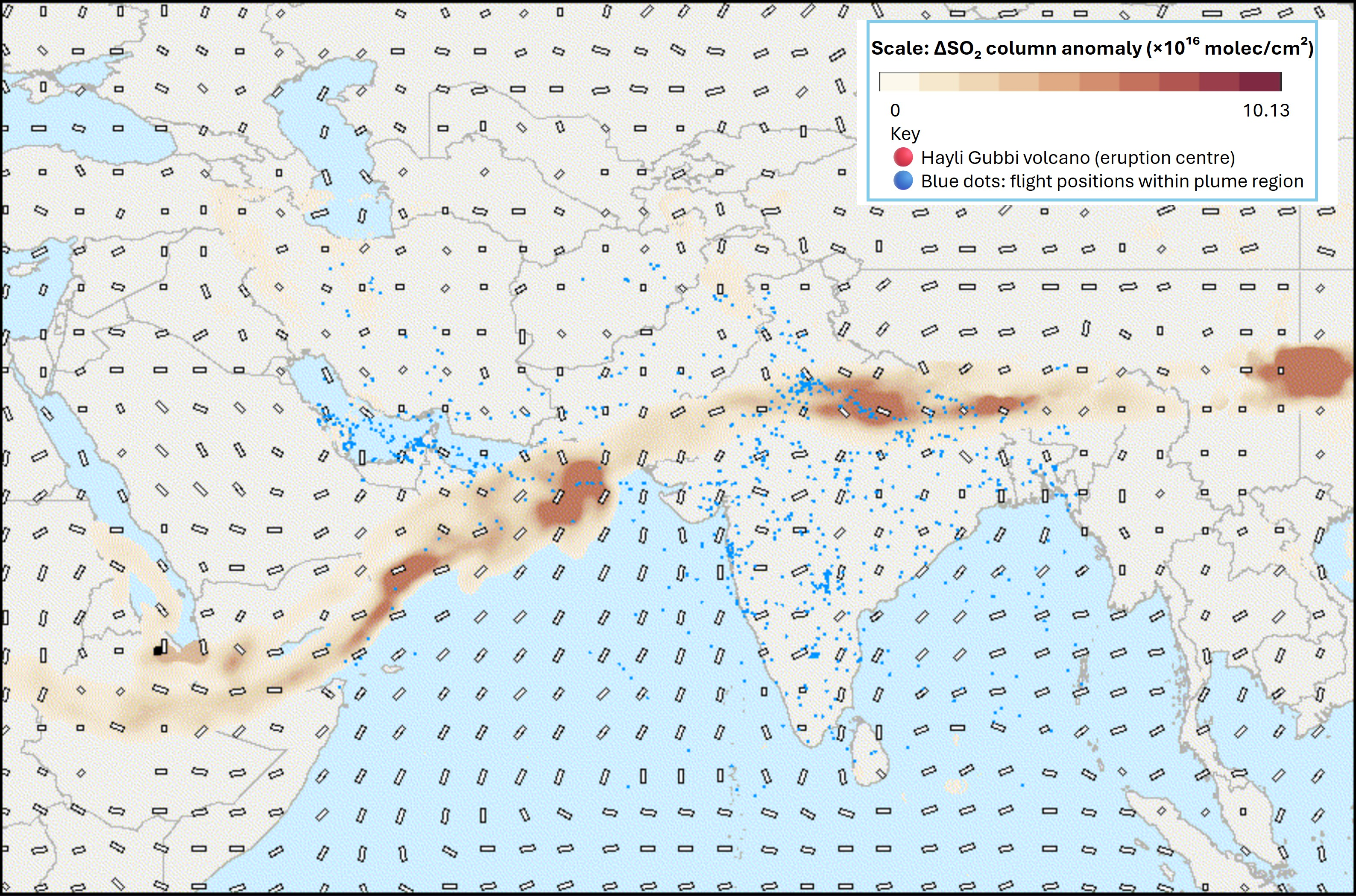
Figure 2: Satellite-derived SO₂ concentration map integrated with ADS-B aircraft trajectories and modeled wind fields, providing operational context on plume transport and potential intersections with active flight corridors.
Rapid damage assessment following major disasters is a time-critical challenge in which automated analysis must operate under uncertainty, incomplete information, and rapidly changing conditions. High-resolution satellite imagery can provide broad situational awareness across affected areas, but converting these observations into reliable building-level damage information often requires a combination of machine learning and targeted human validation.
An illustrative example is Microsoft AI for Good Lab’s High-speed Assessment and Satellite Tracking for Emergencies (HASTE) framework [3] . HASTE is designed to accelerate post-disaster assessment by combining AI-assisted building analysis with interactive human labeling. Rather than requiring exhaustive manual review of entire satellite scenes, the workflow enables analysts to inspect, validate, and correct selected building-level predictions, progressively improving the quality of the resulting damage assessment.
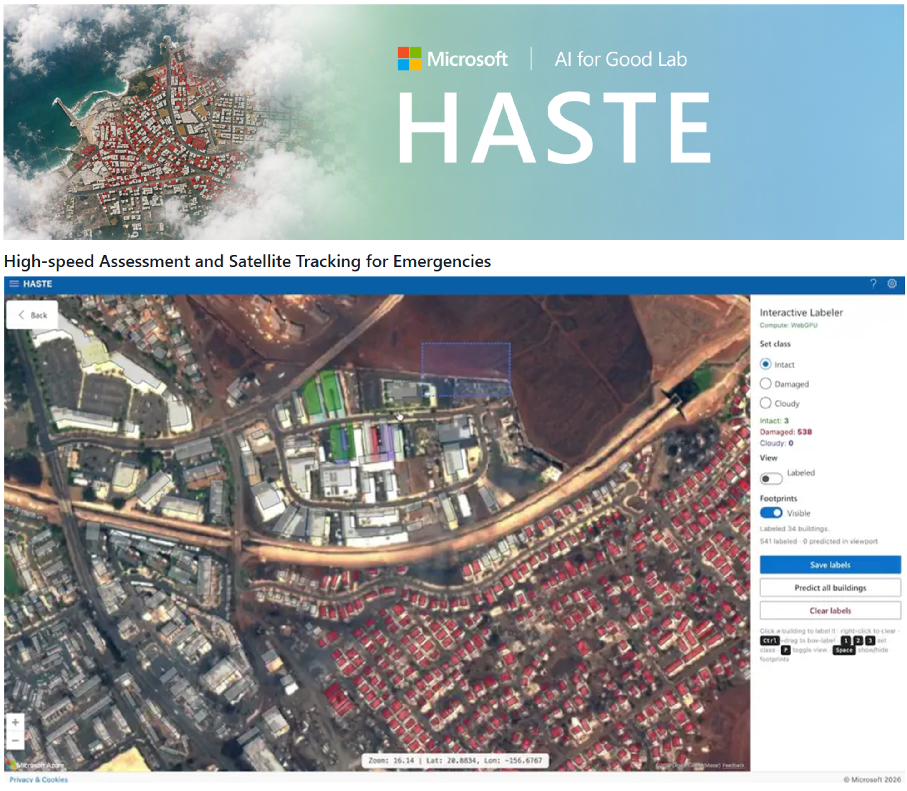
Figure 3: HASTE (High-speed Assessment and Satellite Tracking for Emergencies), developed by Microsoft’s AI for Good Lab, illustrating an interactive human-in-the-loop workflow for labeling buildings and supporting rapid AI-assisted post-disaster damage assessment. Source: Microsoft AI for Good Lab, HASTE
This human-in-the-loop approach is particularly valuable in disaster environments, where cloud cover, image quality, varying building types, and complex damage signatures can limit the reliability of fully automated classification. Human validation can therefore be directed toward uncertain or operationally important areas, allowing automated models to provide scale while analysts contribute contextual judgment and quality control.
From an architectural perspective, HASTE illustrates an important principle for next-generation EO intelligence systems: human expertise can be integrated directly into the analytical loop rather than applied only after automated processing is complete. In an agentic architecture, uncertainty estimates, disagreement between models, or mission priorities could be used to determine where human review is most valuable. Validated observations could then be fed back into the analytical workflow to refine classifications, update confidence levels, and guide subsequent analysis or data acquisition.
A related operational example followed the 2026 Venezuela earthquake, where high-resolution satellite imagery made available through the Vantor Open Data program [4] was analyzed using AI-based building detection and damage classification. The workflow automatically identified building footprints and classified affected structures by damage severity, including full and partial damage categories, with the resulting detections visualized spatially to support rapid interpretation of affected areas (Figure 4). This example illustrates how timely commercial satellite imagery can be combined with automated analytics to transform post-event observations into structured, building-level damage information. Such workflows can further incorporate targeted human validation to review uncertain classifications and prioritize areas requiring closer examination.
However, the workflow of an end-to-end agentic intelligence platform does not end with damage assessment. Based on the identified damage, affected infrastructure, accessibility constraints, and evolving operational conditions, the system can support course-of-action generation by identifying relevant authorities for alerting, highlighting potentially affected or unsafe road segments, recommending viable evacuation or access routes, and identifying nearby accommodation, medical facilities, or temporary shelter options. These recommendations can be continuously updated as new observations and operational data become available, while remaining subject to human validation and authorization before operational action.
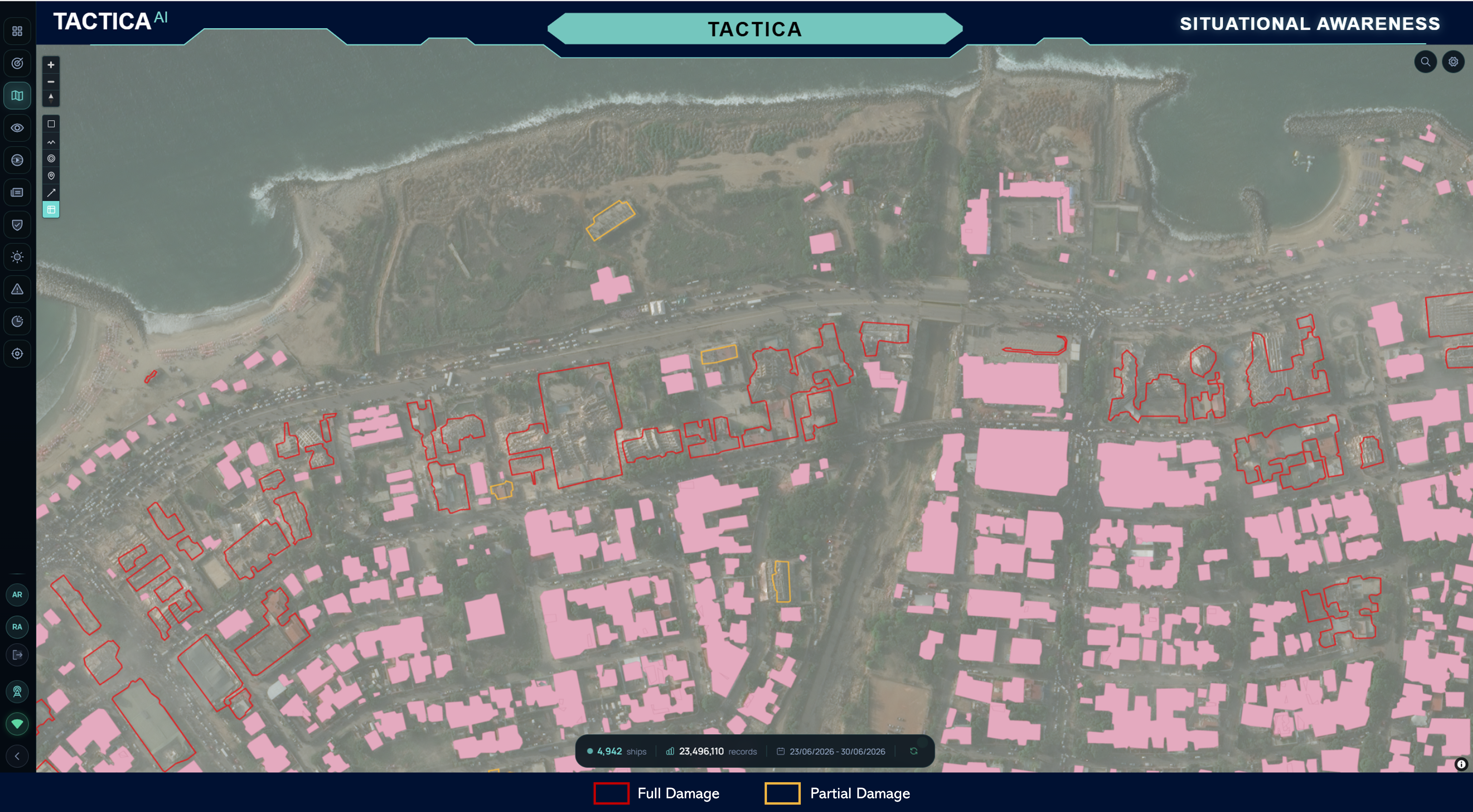
Figure 4: AI-assisted building detection and damage classification applied to high-resolution post-event satellite imagery following the 2026 Venezuela earthquake. Detected building footprints are spatially classified by damage severity, illustrating the transformation of satellite imagery into structured building-level information for rapid damage assessment. Source: Authors’ analysis; satellite imagery made available through the Vantor Open Data program.
Such workflows point toward a broader model for disaster intelligence in which AI, geospatial analytics, commercial and public Earth Observation data, and human expertise operate as a continuous feedback loop. The objective is not to remove the analyst from the process, but to focus human attention where judgment has the greatest operational value while allowing automated systems to accelerate large-scale assessment.
Oil spill monitoring has evolved from manual radar inspection toward scalable, automated intelligence systems. A notable example is SkyTruth’s Cerulean platform, which uses Sentinel-1 Synthetic Aperture Radar (SAR) imagery to detect and map marine oil slicks at scale [5] . SAR’s sensitivity to surface roughness enables oil films to appear as dark formations caused by the damping of capillary waves, supporting day-night and all-weather monitoring of potential pollution events.
Cerulean operationalizes this capability through automated workflows that identify candidate slicks, delineate their spatial extent, and characterize attributes such as location, length, and area. The workflow then extends beyond detection by integrating contextual maritime and environmental information, including vessel activity, wind conditions, and ocean current and tidal data. These complementary layers can help interpret the likely transport and evolution of a detected slick and support the identification of potential pollution sources by relating slick geometry and location to vessel trajectories and other offshore assets.
The integration of vessel information adds an important intelligence layer to the workflow. Potential source vessels can be linked with identifying and operational information—including vessel name, Maritime Mobile Service Identity (MMSI), International Maritime Organization (IMO) number, flag state, vessel type, historical trajectory, and Automatic Identification System (AIS) behavior. This enables analysts to move from observing an anomalous feature in a SAR image toward reconstructing the broader operational context surrounding a pollution event. Potential source associations can therefore be investigated not only through spatial proximity, but also by examining vessel trajectories, AIS behavior, and the environmental conditions influencing slick drift and dispersion.
This workflow reflects a broader architectural shift from image-centric analysis toward structured maritime intelligence. Rather than delivering a static radar scene or isolated detection, the system connects observation, detection, characterization, source attribution, and contextual investigation within a traceable analytical workflow. Such an approach illustrates how Earth Observation analytics can be combined with maritime data and contextual intelligence to support persistent environmental monitoring, investigation, and regulatory action.
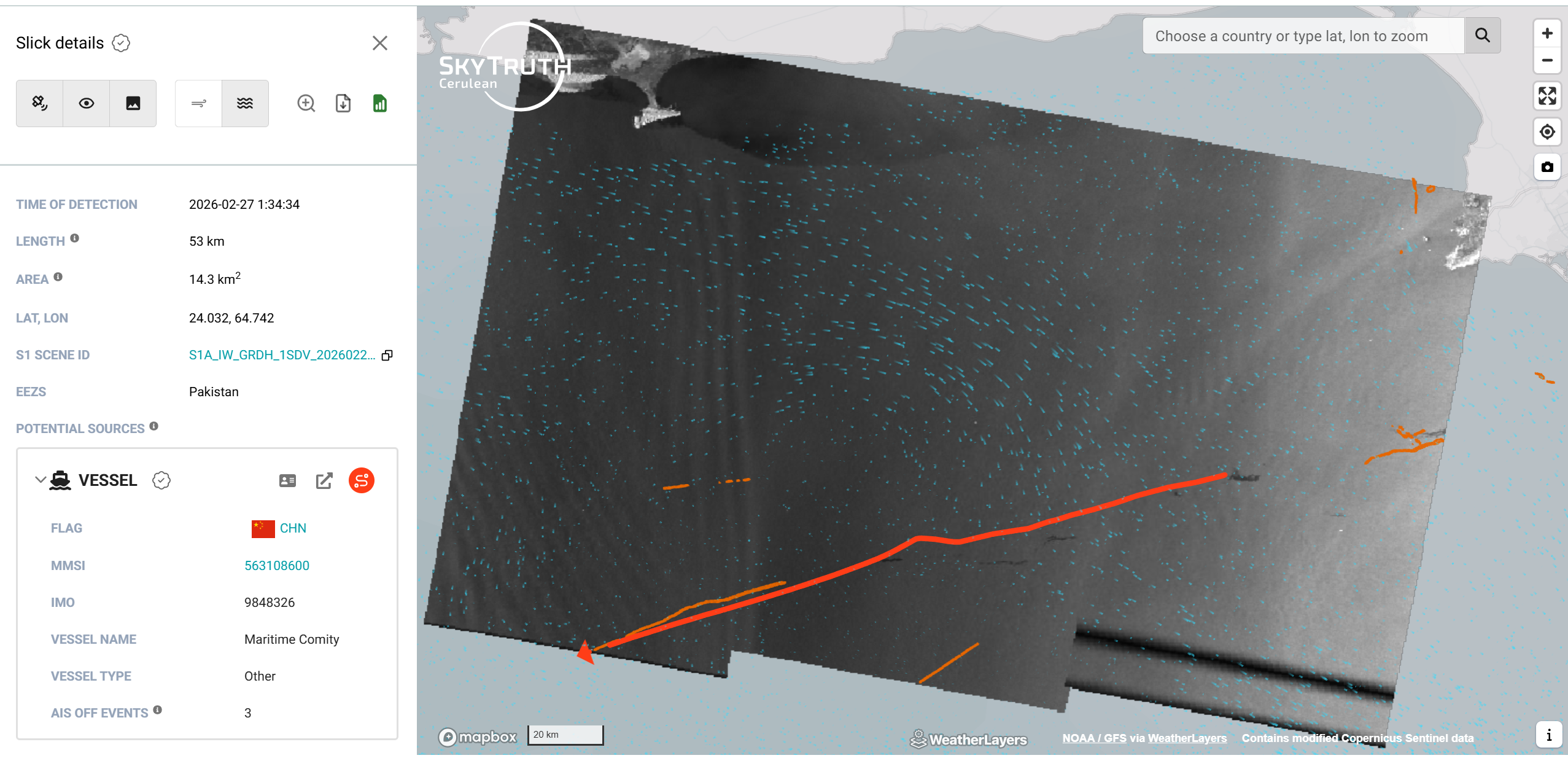
Figure 5: Operational oil spill intelligence workflow in the SkyTruth Cerulean platform, illustrating Sentinel-1 SAR-based slick detection and characterization, environmental overlays including wind and ocean conditions, and potential source attribution through contextual vessel information and trajectory analysis. Image credit: SkyTruth.
Critical infrastructure networks—including bridges, airports, highways, railways, and ports—extend across large geographic areas and are difficult to monitor continuously using ground-based inspection alone. Multi-temporal Interferometric Synthetic Aperture Radar (InSAR) provides a complementary capability for detecting and tracking surface deformation over time, enabling persistent, wide-area screening of infrastructure assets and their surrounding terrain.
Operational platforms such as Value.Space illustrate how satellite-derived deformation measurements can be transformed from specialist geospatial products into accessible infrastructure-monitoring information [6] . Rather than presenting InSAR outputs solely as static raster layers, such platforms enable users to inspect spatially distributed measurement points, identify localized deformation patterns, and examine displacement histories at selected locations. This makes persistent satellite monitoring more accessible for asset screening and the identification of areas that may warrant further engineering investigation.
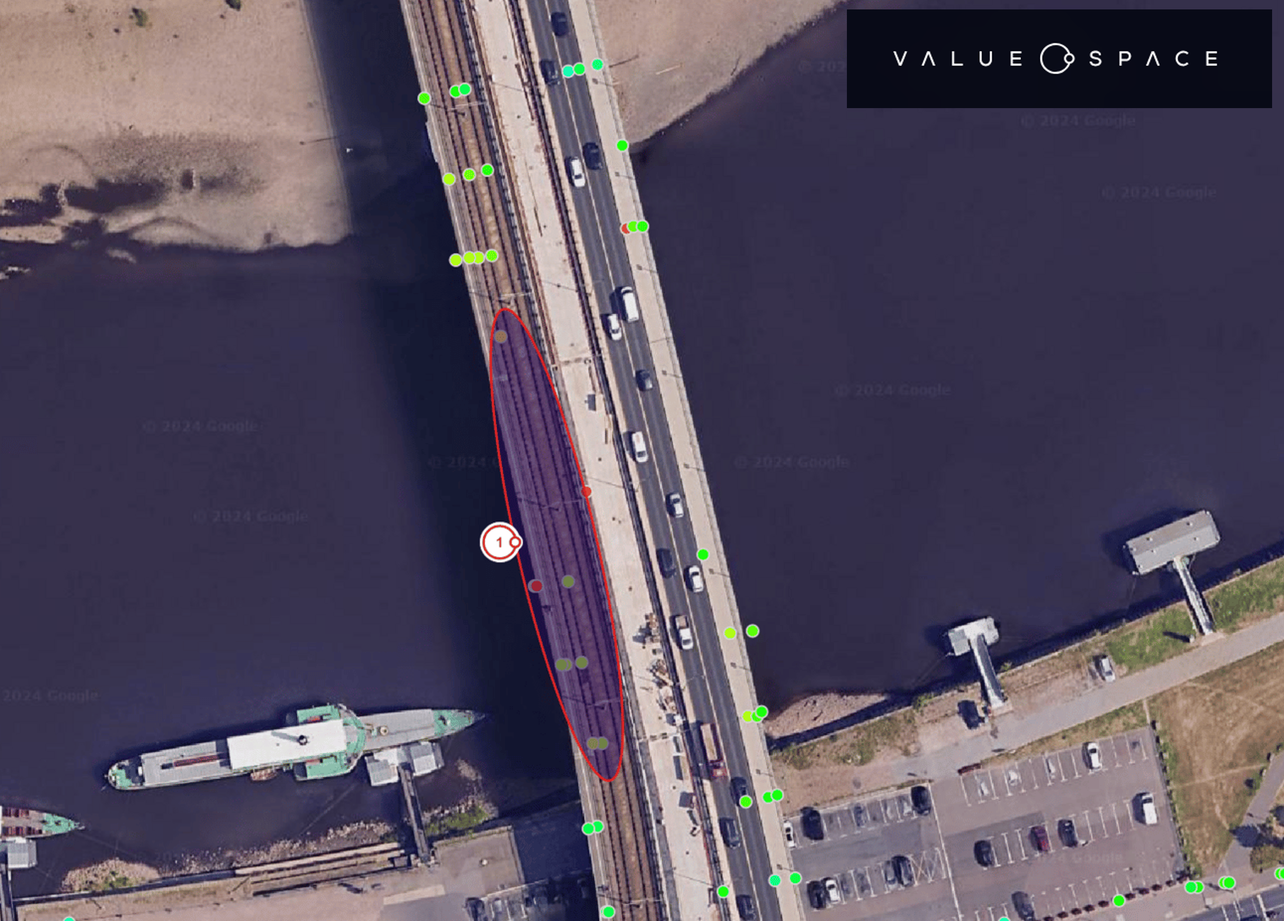
Figure 6: Satellite-based deformation monitoring of the Carola Bridge in Dresden, showing localized InSAR measurement points and an area of observed movement along the bridge section that subsequently collapsed. The example illustrates how persistent satellite monitoring can highlight localized deformation patterns that may warrant further engineering investigation. Image credit: Value.Space.
The 2024 partial collapse of the Carola Bridge in Dresden illustrates the broader relevance of this capability. Official engineering assessments attributed the failure primarily to structural mechanisms including stress corrosion cracking and long-term deterioration [7] . InSAR cannot directly diagnose such internal failure mechanisms. However, satellite-based analyses highlighted measurable deformation trends in the bridge corridor prior to the collapse, demonstrating how persistent remote monitoring can provide complementary indicators of anomalous motion. Such indicators do not constitute a prediction of structural failure, but they may provide additional evidence for prioritizing assets for closer engineering assessment.
The operational challenge at larger scales extends beyond inspecting individual deformation points. Dense InSAR measurements must be associated with the physical infrastructure assets they represent before they can support systematic engineering decision-making. In an asset-centric workflow, infrastructure such as bridges, roads, railways, airports, and ports can first be identified and segmented using geospatial data and AI-based feature extraction. InSAR measurement points can then be spatially associated with individual assets, enabling displacement trends, Line-of-Sight velocities, temporal coherence, and anomalous motion patterns to be assessed at the asset level rather than as isolated measurements.
The TACTICA workflow illustrates this progression toward scalable infrastructure intelligence. By combining infrastructure segmentation with InSAR-derived measurements, large numbers of distributed assets can be continuously screened and categorized according to observed deformation behaviour. Assets exhibiting stable measurements can remain under routine monitoring, while those showing persistent, accelerating, or otherwise anomalous displacement trends can be prioritized for further review. Instead of requiring engineering teams to manually inspect large volumes of InSAR measurements, the workflow can surface higher-priority assets, provide access to their deformation histories, and support alerts when defined risk criteria or anomalous trends are identified.
Within an agentic intelligence architecture, this workflow can extend from infrastructure identification and segmentation to deformation monitoring, anomaly detection, asset prioritization, and engineering notification. Relevant contextual information—including asset type, location, historical deformation, surrounding ground motion, and previous observations—can be assembled into an intelligence package for engineering teams. Importantly, these outputs should be interpreted as indicators requiring further investigation rather than as diagnoses of structural failure. InSAR provides evidence of surface motion, while determination of structural condition and root cause remains dependent on engineering inspection and complementary monitoring data.
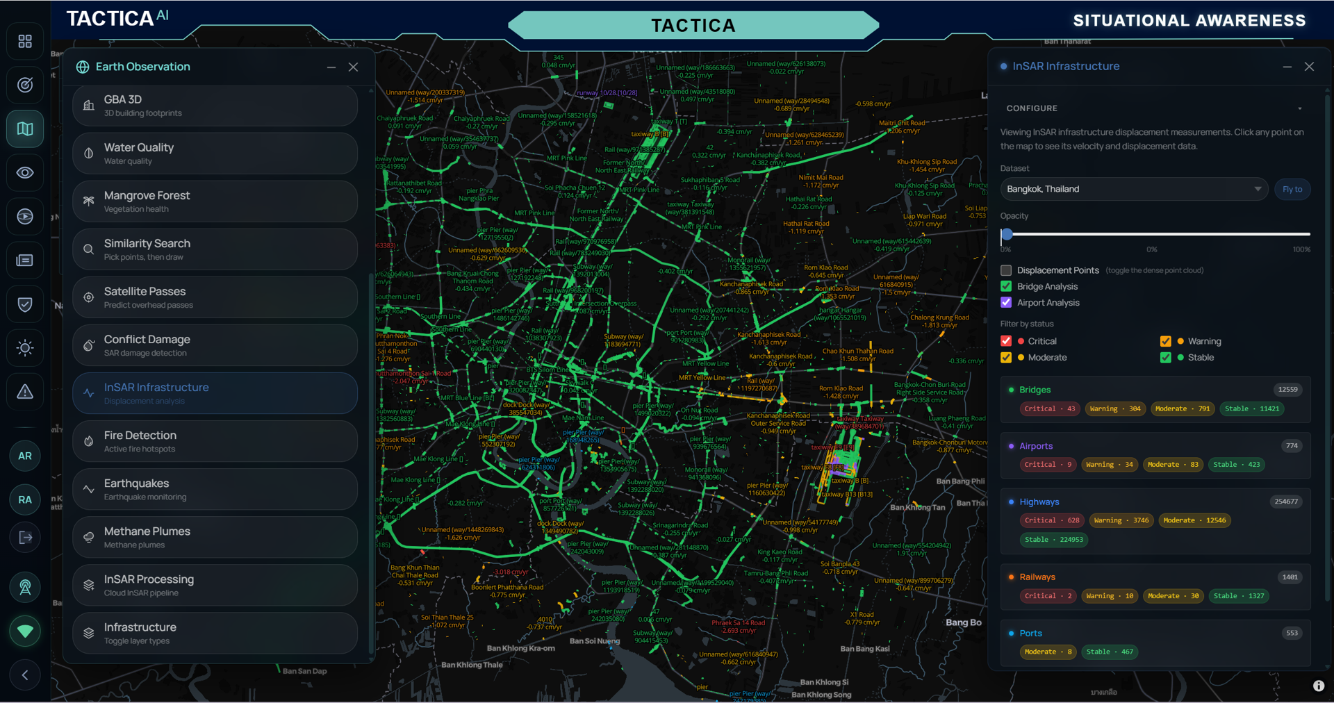
Figure 7: Asset-centric infrastructure monitoring workflow integrating segmented infrastructure assets with InSAR-derived deformation measurements. Bridges, airports, highways, railways, and ports are screened and prioritized according to observed motion patterns, supporting anomaly identification, targeted engineering review, and alerting. Source: TACTICA.
Maritime Domain Awareness (MDA) extends beyond the detection and tracking of vessels. A comprehensive maritime picture requires an understanding of the physical environment in which maritime activity occurs, the infrastructure and access conditions that enable it, and the behavioral patterns that may indicate changes in operational activity. This requires the fusion of heterogeneous information sources, including satellite imagery, Automatic Identification System (AIS) data, vessel and ownership information, navigational charts, bathymetry, shoreline information, and oceanographic and meteorological conditions.
Earth Observation contributes several complementary intelligence layers to this broader picture. Optical and radar satellite imagery can support vessel detection, coastal and shoreline change analysis, oil spill monitoring, infrastructure observation, and the identification of maritime activity independent of cooperative reporting systems. Cross-correlation of satellite-detected vessels with AIS broadcasts can help identify potentially non-transmitting or “dark” vessels, while analysis of inconsistencies between reported AIS positions, vessel trajectories, and independent observations can support the identification of anomalous behavior and potential AIS spoofing. Environmental layers, including winds, currents, tides, waves, and sea state provide additional context for interpreting both vessel activity and evolving maritime events. Together, these capabilities illustrate the transition from individual EO products toward persistent, multi-source maritime intelligence.
Hydrographic and bathymetric information represents another important component of this operational picture. Water depth, dredged channels, shoreline modification, and changes in coastal infrastructure directly influence navigational accessibility and the classes of vessels capable of operating within an area. Satellite-derived bathymetry (SDB) provides a complementary capability for monitoring shallow-water environments using multispectral imagery, particularly where repeated conventional hydrographic surveys may be unavailable. Multi-temporal analysis can reveal changes in seabed morphology, dredging activity, channel development, and sediment redistribution.
An illustrative example is the analysis of Barque Canada Reef in the South China Sea, where satellite-derived bathymetry was applied to multispectral imagery acquired in 2020 and 2024. The comparative depth maps reveal substantial modification of the shallow-water environment over the four-year period. A defined channel-like feature is visible in the 2024 dataset that was absent or significantly shallower in the 2020 baseline, with observed depth gradients consistent with seabed modification and sediment redistribution. LiDAR reference measurements were used to support calibration and validation of the depth retrieval.
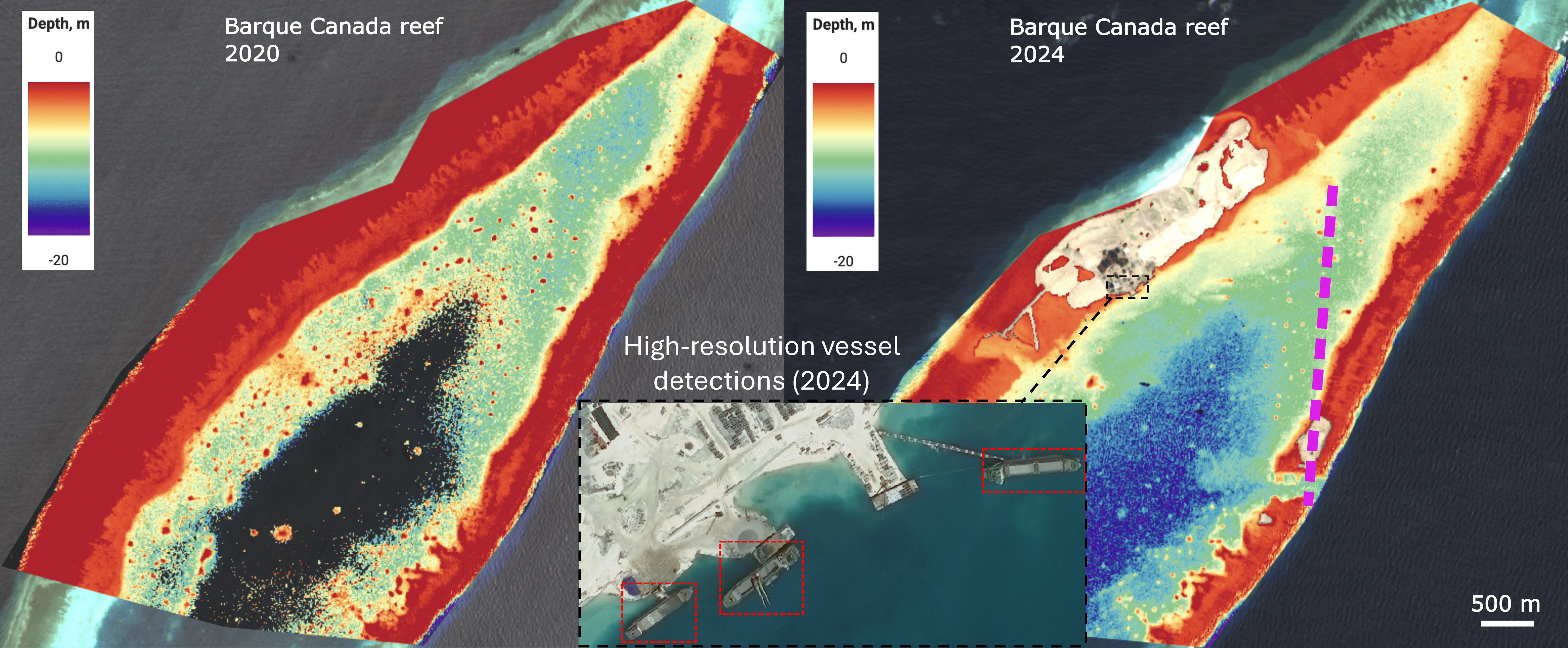
Figure 8: Multi-source Earth Observation analysis of Barque Canada Reef. Satellite-derived bathymetry from 2020 and 2024 illustrates changes in shallow-water morphology and the development of a defined channel-like feature, while high- resolution satellite imagery identifies several vessels for which no corresponding AIS signals were identified. Together, these observations demonstrate how bathymetric change, coastal modification, and independent vessel detection can contribute to a broader Maritime Domain Awareness picture. The dashed magenta line denotes the LiDAR reference track.
Importantly, the intelligence value extends beyond detecting physical change. Estimated channel depths can help assess navigational accessibility and constrain the approximate draft and therefore potentially the classes of vessels capable of entering or operating within a modified area. Satellite imagery of the area also enabled the detection of several vessels for which no corresponding AIS signals were identified, illustrating the value of combining independent EO-based observations with cooperative vessel-reporting systems. When considered together with observed channel modification, vessel detections, AIS information, navigational charts, infrastructure observations, and environmental conditions, these complementary sources provide a more comprehensive understanding of evolving maritime access and activity.
At a broader operational scale, MDA platforms increasingly integrate vessel movement histories with contextual and predictive analytics to support continuous monitoring and decision-making. Platforms such as Windward and TACTICA illustrate different implementations of this broader multi-source intelligence model. Windward demonstrates how maritime data can be transformed into operational insights across vessel and shipment activity, including route monitoring, port calls, estimated arrival times, disruptions, and other indicators relevant to maritime operations and supply-chain visibility [8] . By combining historical and current movement information with analytical and predictive capabilities, such systems move beyond displaying vessel positions toward interpreting the operational significance of maritime activity.
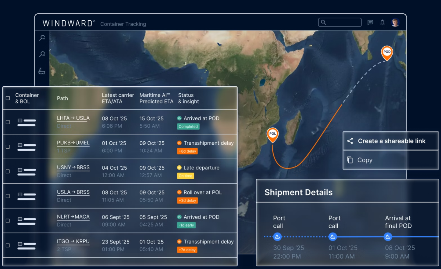
Figure 9: Example of an operational maritime intelligence environment integrating vessel and shipment movement information with route, port-call, status, and predictive arrival insights to support maritime monitoring and decision- making. Source: Windward.
The same broader architectural direction extends to mission-oriented investigation of maritime activity. Within an integrated MDA environment, vessel tracks and activity histories can be correlated across a defined geographic region and time window to investigate behaviors such as AIS transmission gaps, unexpected route changes, loitering, rendezvous patterns, or potentially “dark” activity. Satellite-based vessel detections can be compared with AIS broadcasts to identify missing or inconsistent signals, while discrepancies between reported positions and independent observations may warrant further investigation for potential AIS anomalies or spoofing. Environmental and operational context can further support interpretation and prioritization of events requiring additional analysis.
As illustrated by TACTICA, natural-language interaction can provide an additional interface to this multi-source intelligence environment. Rather than requiring an analyst to manually navigate individual data layers and construct each query independently, a mission-oriented question can be translated into the relevant spatial, temporal, and behavioral analyses. In the example shown, an analyst investigates vessels that experienced AIS transmission gaps within the Strait of Hormuz over a specified period, with the resulting assessment linked to the underlying activity and evidence. Such interfaces illustrate how AI-assisted orchestration can help analysts navigate complex maritime datasets, investigate emerging patterns, and transform heterogeneous observations into structured intelligence while retaining human oversight and access to supporting evidence.
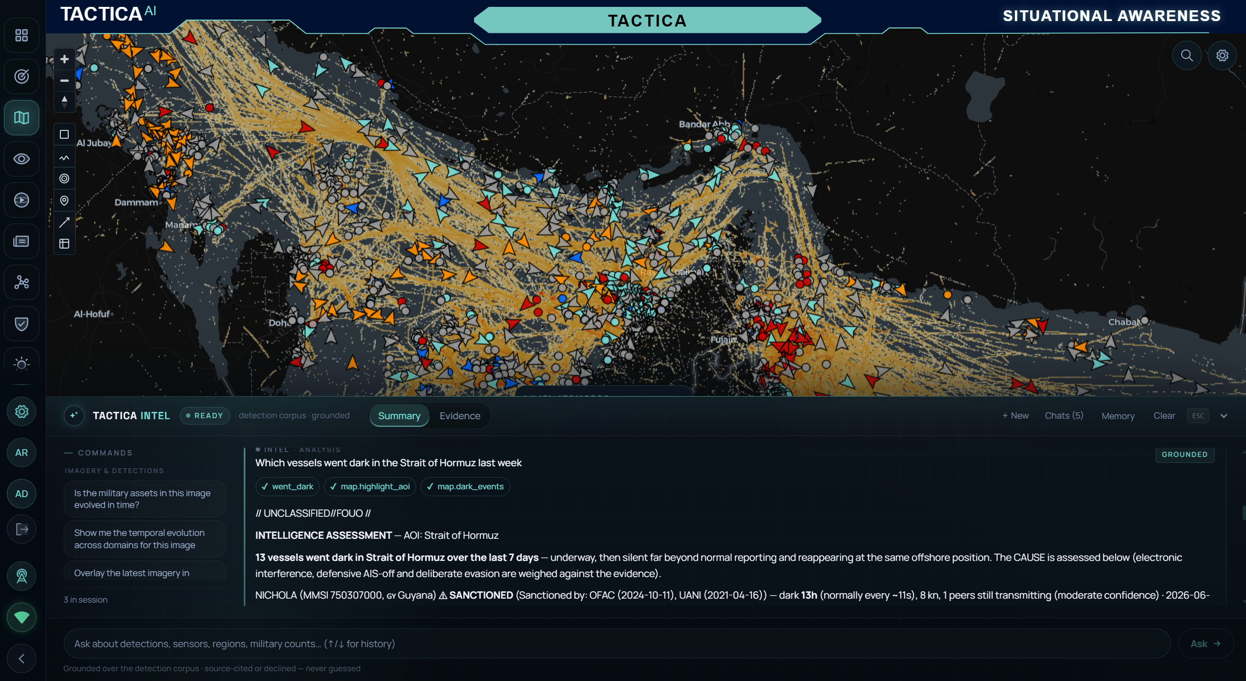
Figure 10: Example of an AI-assisted Maritime Domain Awareness environment combining vessel tracks, activity histories, and geospatial context within a common operational picture. A natural-language intelligence interface supports mission- oriented investigation of vessel behavior, illustrated here through the assessment of AIS transmission gaps and potentially “dark” activity within a defined geographic region and time period. Source: TACTICA.
Taken together, these examples illustrate the evolution of MDA from a collection of separate surveillance feeds toward an integrated understanding of the maritime environment, infrastructure, access conditions, vessel presence, identity, behavior, and operational context. The Barque Canada Reef example demonstrates how changes in the physical environment can be combined with independent vessel detection and AIS correlation to reveal evolving patterns of maritime access and activity. Operational platforms such as Windward and TACTICA further illustrate how maritime data, behavioral and contextual analytics, predictive capabilities, and AI-assisted investigation can contribute to a persistent and continuously evolving maritime intelligence picture. The objective is therefore not simply to observe maritime activity, but to connect heterogeneous observations across space and time so that significant changes, anomalies, and emerging risks can be identified, investigated, and communicated in a decision-relevant form.
Beyond traditional Earth Observation–centric systems, geospatial platforms demonstrate how heterogeneous spatial datasets can be integrated to support complex decision workflows. One illustrative example is VFMatch.org, developed by the Virtue Foundation in collaboration with CARTO [9] . The platform combines healthcare facility locations, population distribution, accessibility constraints, and infrastructure proximity to identify medically underserved regions, or “medical deserts,” at multiple spatial scales.
Through interactive filtering and spatial analysis, users can explore healthcare gaps according to facility type, population distribution, and distance thresholds, helping identify areas where access to medical services may be limited. The platform demonstrates how cloud-native spatial analytics, layered geospatial visualization, and scalable data integration can transform heterogeneous datasets into decision-relevant information for resource allocation and humanitarian planning.
Although VFMatch is not an Earth Observation–native platform, it illustrates an important principle for next-generation geospatial intelligence: the value of spatial data emerges through contextual integration and mission-oriented reasoning rather than from any single sensing modality. EO-derived information—such as population and settlement change, transportation accessibility, disaster exposure, environmental conditions, or infrastructure development—can complement administrative and socioeconomic datasets to enrich such decision workflows.
Within an agentic geospatial architecture, this concept can be extended further. Rather than relying solely on predefined filters, an AI-enabled system could interpret a user objective, identify and retrieve relevant spatial datasets, invoke appropriate geospatial analyses, evaluate accessibility and risk constraints, and synthesize the results into prioritized recommendations. VFMatch therefore provides an illustrative foundation for how integrated geospatial data and spatial reasoning can evolve toward more adaptive, mission-driven decision-support systems.
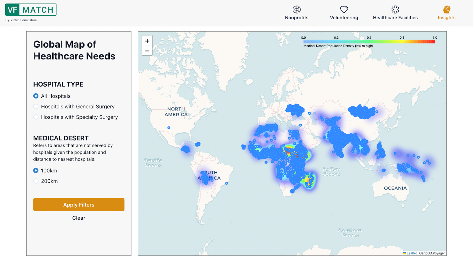
Figure 11: Global healthcare access visualization from the VFMatch platform, highlighting medically underserved regions based on population distribution and hospital proximity. Source: Virtue Foundation / CARTO (VFMatch.org).
Finally, bringing these capabilities together requires systems that can connect a user’s operational intent not only to geospatial analysis, but also to the acquisition of new observations. This represents an important evolution in Earth Observation: from systems that help users analyze available data toward architectures that can also identify information requirements and support the planning of what should be observed next.
Emerging platforms such as Klarety AI illustrate the first part of this transition through natural-language-driven geospatial analysis [10] . A user-defined objective can initiate a sequence of data discovery, ingestion, spatial analysis, modelling, and synthesis steps without requiring the user to manually construct each underlying GIS workflow. In this interaction model, agentic AI acts as an orchestration layer between mission intent and analytical capabilities, coordinating data and computational tools to produce decision-relevant outputs.
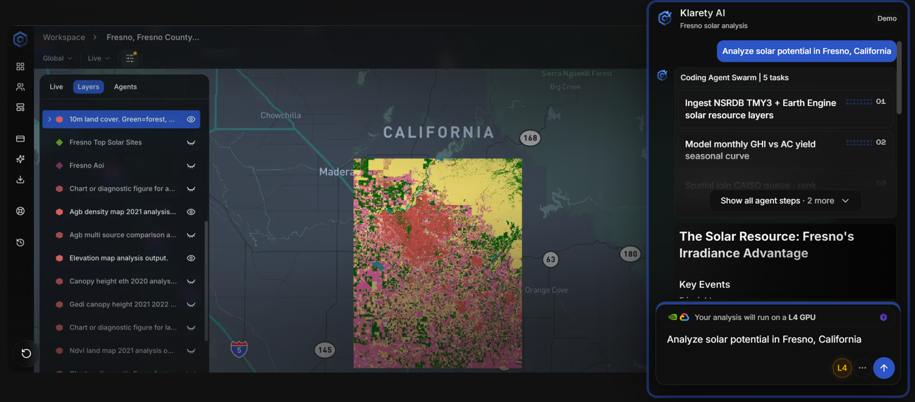
Figure 12: Klarety AI interface illustrating natural-language-driven orchestration of geospatial data and analytical workflows, where a user-defined objective initiates a sequence of data ingestion, modelling, spatial analysis, and synthesis. Source: Klarety AI.
The same intent-driven principle can extend upstream from analysis to satellite collection planning. Conventional commercial tasking platforms such as Vantor’s Tensorglobe™ provide the operational infrastructure through which users can define areas of interest and configure acquisition parameters such as collection windows, cloud-cover constraints, viewing geometry, sensor availability, and product requirements [11] . These capabilities are essential for translating a collection requirement into an executable satellite acquisition request.
Agentic AI introduces an additional orchestration layer above this process. Rather than requiring users to manually translate a high-level operational objective into individual areas of interest and detailed acquisition parameters, an agentic system can assist in decomposing mission intent into a structured collection strategy. A natural-language objective can be interpreted to identify relevant locations, create geographic areas of interest, determine suitable sensing modalities, define revisit and quality requirements, and evaluate candidate acquisition opportunities.
TACTICA OrbitIQ illustrates this emerging approach to mission-driven collection planning. In the example shown, a user specifies a monitoring objective in natural language involving multiple airports across several countries, together with revisit and quality requirements. The planning assistant identifies the relevant infrastructure, creates corresponding areas of interest, configures planning parameters, and initiates the mission-planning workflow. Candidate acquisition opportunities can subsequently be evaluated across available optical and SAR imagery providers.
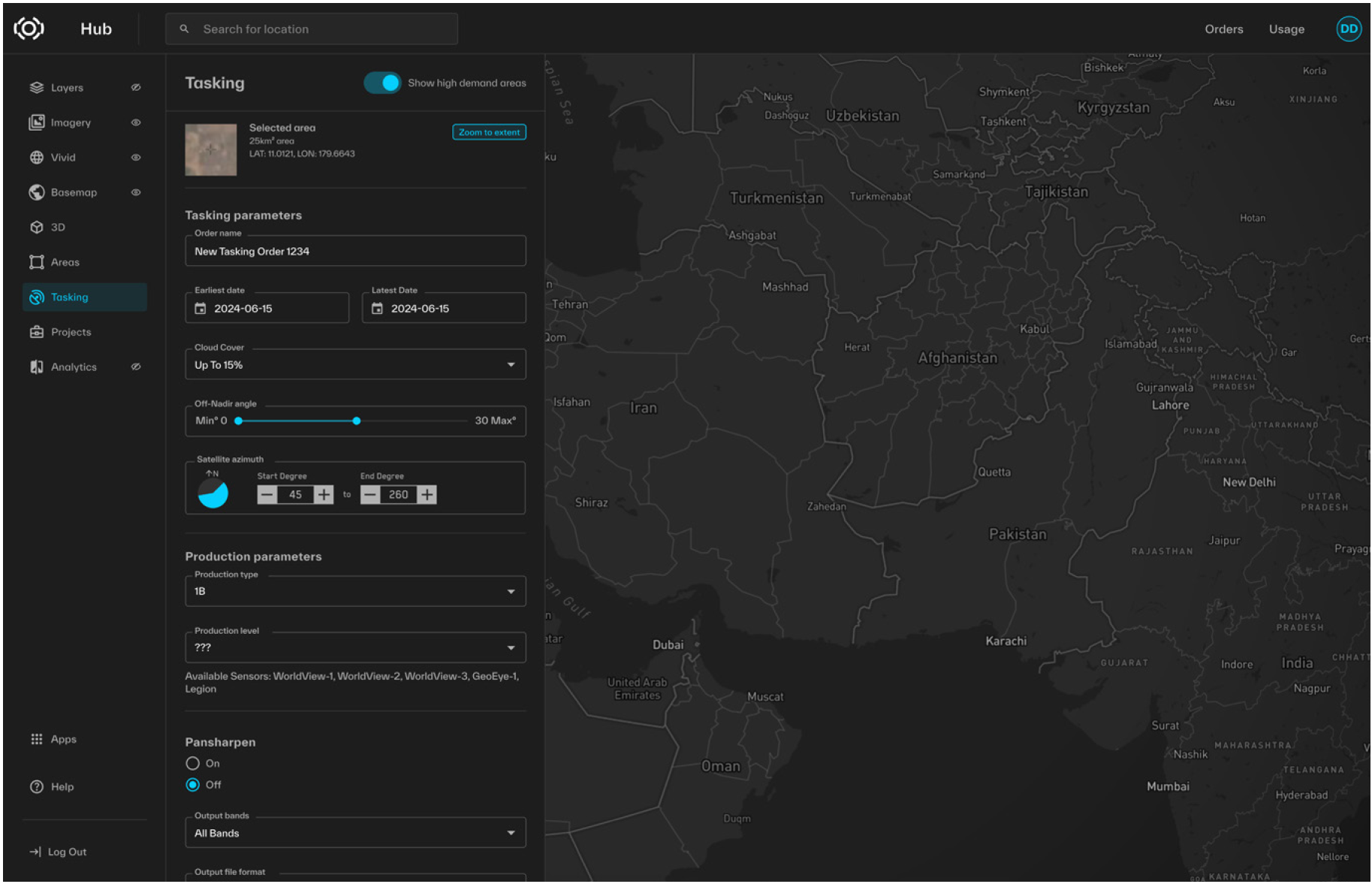
Figure 13: Vantor Tensorglobe™ interface illustrating parameter-driven satellite imagery tasking, including area-of-interest selection and acquisition constraints. Source: Vantor.
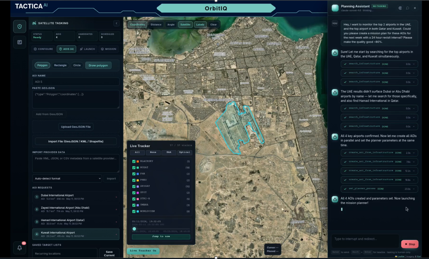
Figure 14: TACTICA OrbitIQ illustrating natural-language-driven mission planning, where a high-level monitoring objective is translated into geographic areas of interest and collection requirements for planning across multiple optical and SAR imagery providers. Source: TACTICA AI.
The significance of this evolution lies in connecting mission intent, analysis, information requirements, and collection planning within a continuous operational loop. Analytical findings may reveal uncertainty or generate new information requirements; those requirements can inform subsequent collection priorities; and newly acquired observations can trigger further analysis. For example, a detected infrastructure anomaly, emerging maritime event, or rapidly evolving disaster may generate a requirement for higher-resolution imagery, a different sensing modality, or increased revisit frequency.
Together, platforms such as Klarety AI, Vantor’s Tensorglobe™, and TACTICA OrbitIQ illustrate different stages of this emerging architecture. Klarety AI demonstrates intent-driven orchestration of geospatial analysis; Tensorglobe™ provides operational mechanisms for imagery discovery and tasking; and TACTICA OrbitIQ demonstrates how natural-language mission objectives can be translated into structured collection-planning requirements. These capabilities need not reside within a single platform to illustrate the broader architectural direction: the progressive connection of analytical reasoning with the acquisition of new observations.
This closes an important loop in next-generation EO intelligence systems. The objective is not to remove analysts or operators from the process, but to reduce the effort required to translate operational questions into analytical workflows and, where existing information is insufficient, into executable observation strategies. By connecting mission intent, analytical reasoning, and sensor tasking within a continuous human-supervised cycle, EO systems can move beyond passive observation toward adaptive intelligence—continuously determining not only what the available data reveal, but what must be observed next to support the decision at hand.
As Earth Observation systems evolve, their value increasingly lies not in isolated analytics, but in their ability to fuse information across domains and translate observations into decision-relevant intelligence. Cross-domain fusion—the integration of EO data with complementary sources such as maritime signals, urban sensing, environmental telemetry, and contextual models—enables a more complete and adaptive understanding of events unfolding across air, land, and sea.
The next generation of EO intelligence systems will be defined by their ability to reason across domains, manage uncertainty explicitly, and adapt workflows dynamically as conditions change. Agentic architectures provide a foundation for this transition, moving beyond linear processing pipelines toward systems capable of coordinating analytical components in response to evolving context. Models and analytical tools are treated not as isolated capabilities, but as interoperable components within a broader reasoning and orchestration framework.
Large language models (LLMs) and emerging GeoLLMs can play a supporting role within this architecture—not as autonomous decision-makers, but as synthesis and coordination layers that help structure complex geospatial evidence, summarize uncertainty, enable natural-language interaction, and support contextual interpretation. Combined with specialized analytical models, geospatial tools, external data services, and sensing systems, these capabilities can support workflows that are progressively assembled and adapted around operational objectives.
Within such systems, EO analytics operate alongside complementary intelligence streams rather than in isolation. Environmental signals derived from satellite imagery can be interpreted in conjunction with mobility data, infrastructure context, meteorological drivers, and domain-specific constraints to assess potential impact and downstream risk. Agentic orchestration enables these relationships to be evaluated as new information becomes available, supporting progressive refinement of situational awareness. Analytical findings can also generate new information requirements, linking interpretation back to data discovery, collection planning, and sensor tasking. This creates the potential for a continuous, adaptive intelligence cycle in which new observations refine analysis and analysis, in turn, helps determine what should be observed next. Crucially, this paradigm reinforces human–AI collaboration: automated reasoning accelerates correlation, synthesis, and prioritization, while human oversight remains essential for validation, accountability, and policy- sensitive decision-making.
These architectural principles are increasingly being explored in applied geospatial intelligence systems, including platforms such as TACTICA and the other operational examples discussed in this paper. Collectively, they illustrate how heterogeneous sensing, specialized analytics, adaptive orchestration, and human oversight can be brought together within broader operational frameworks. The significance lies not in any single platform or technology, but in the emerging architectural pattern: connecting sensing, analysis, reasoning, decision support, and, where necessary, renewed observation within a coherent intelligence cycle.
Looking forward, the defining question for Earth Observation is no longer simply how many sensors can be launched or how frequently imagery can be refreshed. The central challenge is whether EO systems can transform expanding streams of heterogeneous data into coherent, trustworthy, and actionable intelligence. Technical performance alone is insufficient. Governance, transparency, explainability, provenance, and explicit uncertainty management will shape the degree to which such systems earn institutional trust and societal acceptance.
The future of EO will therefore be defined not merely by higher-resolution sensors or faster revisit cycles, but by architectures capable of sustained reasoning across data, domains, and time. By integrating cross-domain fusion with agentic AI and geospatial reasoning, Earth Observation can evolve from a predominantly retrospective mapping discipline toward a living intelligence infrastructure—one that supports anticipation rather than reaction, resilience rather than remediation, and informed action in the face of increasing global complexity.
[1] Novaspace, Earth Observation Satellite Systems Market Outlook 2024–2033, 2024. [Online]. Available: https://nova.space/press-release/earth-observation-satellites-set-to-triple-over-the-next-decade/
[2] World Economic Forum, Amplifying the Global Value of Earth Observation, 2024. [Online]. Available: https://www.weforum.org/publications/amplifying-the-global-value-of-earth-observation/
[3] Microsoft AI for Good Lab, HASTE: High-speed Assessment and Satellite Tracking for Emergencies – Overview, Microsoft, 2026. [Online]. Available: https://microsoft.github.io/haste/usage/overview.html. Accessed: Jul. 14, 2026.
[4] Vantor, Open Data Program. [Online]. Available: https://www.vantor.com/open-data/
[5] E. Bevan, “Leveling up Cerulean’s ability to reveal stationary polluters,” SkyTruth, Jan. 16, 2025. [Online]. Available: https://skytruth.org/2025/01/leveling-up-ceruleans-ability-to-reveal-stationary-polluters/
[6] Value.Space, “Bridge Collapse in Germany: Atypical Movement Detected Almost Two Years Before,” Value.Space Business Update, Sep. 17, 2024. [Online]. Available: https://newsletter.value.space/p/bridge-collapse-germany-atypical-movement-detected-almost-two-years
[7] A. Tunnicliffe, “Dresden bridge failure caused by hydrogen-induced stress corrosion report confirms,” New Civil Engineer, Dec. 19, 2024. [Online]. Available: https://www.newcivilengineer.com/latest/dresden-bridge-failure-caused-by-hydrogen-induced-stress-corrosion-report-confirms-19-12-2024/
[8] Windward, Maritime AI™ Platform. [Online]. Available: https://windward.ai/ Accessed: Jul. 14, 2026.
[9] CARTO, “VFMatch.org — The First Mapping and Matching Global Health Platform,” CARTO Blog, Oct. 10, 2023. [Online]. Available: https://carto.com/blog/vfmatch-org-the-first-mapping-and-matching-global-health-platform/index.html
[10] Klarity, Klarety AI — Earth’s AI Intelligence Platform, 2026. [Online]. Available: https://klarety.ai/ Accessed: Jul. 14, 2026.
[11] Vantor, Tensorglobe™ — AI-Powered Spatial Intelligence Platform. [Online]. Available: https://vantor.com/
For collaborations, demonstrations, or partnerships across Earth Observation, Maritime, or Security domains